Tuesday's snowstorm was a challenging one for me. The storm tracked hundreds of miles southeast of Connecticut - a track that would ordinarily be a complete miss or just a glancing blow for us. The end result, however, was up to 26.0" of snow in the town of Scotland!

The day before the storm we saw the ingredients coming together for a more substantial system. Even though the storm would pass well out to sea the best "lift" in the atmosphere was going to be displaced far to the north and west of the storm's center. Two bands of stronger lift were well modeled by all of our computer models - one over eastern Massachusetts and another closer to Connecticut. The question was how far west would these bands get? How much sinking air in between bands would result in less snow? How slowly would these bands move? Beyond that another question was what type of snow flakes would we get and how fluffy would the snow be? 10" of snow to 1" of liquid water or 20" of snow to 1" of liquid water? As it turned out we saw both!

Strong low level convergence (effectively air that piles onto itself and has nowhere to go but up) was going to be the big snow producer in New England. Not surprisingly, snowfall totals of up to 31" occured outside of Boston in this big band that stretched from coastal Maine to southeastern Connecticut. Knowing that this would setup was an easy call - but there was some uncertainty as to whether Connecticut would get in on the fun. Locally, the band produced snowfall rates of up to 5" per hour and snowfall totals of over 20" in parts of New London and Windham Counties as it did wobble far enough west to smack us.
In the areas where snowfall rates were less temperatures above 32 degrees and the strong March sun angle resulted in a very low impact storm. Bradley Airport managed 6.9 inches of snow but you wouldn't know it by the roads around Windsor Locks! Same storm in Bridgeport where 5.5" of snow fell but roads were fine. In eastern Connecticut the fluffy 2 feet of snow that fell in some towns compacted rapdily and by mid morning today only about a foot of snow remained.
But what about that second band farther west?
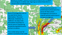
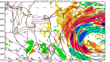
The mechanism for the snow band over western and central Connecticut (it produced 10" of snow in some of the Litchfield Hills and parts of Fairfield County) is something known as frontogenesis. About 10,000 feet above our heads the wind resulted in "deformation". The wind acted to stretch the atmosphere parallell with the temperature gradient which strengthened the temperature gradient between warm air and cold air. Think of it this way, as the atmosphere was being stretched the distance between relatively warm adn relatively cold air was becoming less and less. This is frontogenesis or the stregthening of a font! This results in a thermally direct circulation with warm air rising and cold air sinking on either side of the circulation. The rising side gets a band of very heavy snow (only about 10 miles wide in the case) while the sinking side gets no snow at all.
Local
As always these storms are challenging to predict and figuring out just how far west these snow bands would get was a bear. Take for instance Clinton and Waterford. About 20 miles made the difference between 3.5" and 18.0" of snow. We are very good at predicting whether or not a storm will hit us days ahead of time (though in the 24 hours before the storm a jump in storm track by about 75 miles was critical for us).
The predictability of very small scale circulations that result in narrow bands of heavy snow have an exceptionally short predictability horizon. This gives plenty of fodder for unhappy viewers on social media who have come up with dozens of different ways to call me an idiot for a bad forecast for their backyard (I admire the creativity of some!) but it also provides ample opportunity for improving and learning about these really fascinating features.


