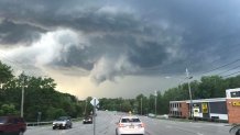
Wednesday's tornado warning was the first here in Connecticut in quite some time. The storm didn't produce a tornado here but did just west of here in Dutchess County, New York. Yesterday I answered a bunch of questions on the severe event but today I wanted to take a closer look at how the tornado itself formed.

The storm produced golf ball size hail and an EF-1 tornado near Poughkeepsie. While the environment seemed fairly hostile to tornado development one managed to form anyway and radar reveals a few possible reasons why. One possible explanation is that the tornado touched down as the a line of thunderstorms moving in from the Catskills was merging with a storm out ahead of it.
Cell mergers are funny things. Sometimes as two storms interact they both manage to weaken. Other times the merger is constructive and the storm manages to increase in intensity. The Dutchess County storm was the latter. There is a marked increase in the intensity of the storm as the merger is underway. Just speculation here but the cell merger may have been able to trigger a tornado and here are possible reasons why.
- There wasn't much low level wind shear out ahead of the line. There was deep layer shear (meaning the storms that were 40,000 feet tall were able to spin) but for tornadoes you really want strong wind shear in the lowest 10,000 feet of the atmosphere. Not all spin is created equal! As the storm interacted with the line merging from the northwest the low level wind shear may have been locally enhanced allowing a tornado to develop in an otherwise hostile environment.
- The storm motion for a period of time was quite deviant to the right as the merger was underway and immediately after. This can also serve to increase storm relative helicity (storm relative wind shear).
- The increase in low level shear happened in tandem with a sizable jump in the storm's updraft.
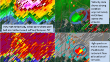
Let's dive into the radar data. The animation at the top of this post shows the storm merger occurring. Below is the radar from Long Island valid at 6:54 p.m. where you can see a sizable velocity couplet. We have a gate-to-gate shear (or delta V) of 61 knots which is higher than most tornadoes in the northeast (the median value is 45 knots). Additionally, you can see a high spectrum width (SW) overhead which indicates turbulent and chaotic flow. SW spiked at the time of the velocity couplet passing over the tornado touchdown location and immediately diminished after the tornado lifted.

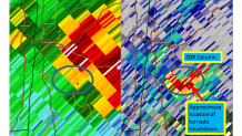
The second radar grab is also around the time of tornado and it shows a spike in differential reflectivity (or ZDR) at 12,200 feet above the ground. This indicates that big liquid water drops were being lofted above the freezing level - and this occurs for only 1 scan - right during tornadogenesis. This ZDR column is a good proxy for the storm's strength and shows a notable brief jump in updraft strength.

It stands to reason that the cell merger increased low level shear AND the increase in the updraft strength that occured simultaneious was enough to result in tornadogenesis - with more efficient vortex stretching and tilting.
Local
Even environments that wouldn't normally support a tornado can when there are complex storm interactions going on. Radar data, in retrospect, gave us a few clues as to what was going on with the storm.


