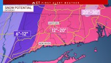
A major nor'easter will develop off the coast of New England this weekend but the storm's track will determine how much snow we see in Connecticut.
There's been a notable jump close to the coast today with the storm track and a growing consensus that this storm will produce significant snowfall and wind. While the heaviest snow is expected to remain to the east, our meteorologists have seen some indications this evening that it may shift closer to the state.
A winter storm watch has been issued for all of Connecticut.

Get top local stories in Connecticut delivered to you every morning. Sign up for NBC Connecticut's News Headlines newsletter.
It appears that the storm will pass close enough to us to bring six inches to a foot of snow to eastern Connecticut. Areas west of Interstate 91 could see anywhere from three to six inches of snow.
That track of the storm makes it less likely for us to see blizzard conditions in Connecticut, but still brings accumulating snow and gusty winds to the state.
Eversource said it is positioning equipment and line and tree crews across the state, including hundreds of additional out-of-state crews, to respond to any potential storm-related outages.
Local
"We have hundreds of crews flying in throughout the day today – and more arriving tomorrow – from southern and western parts of the country, so we don’t have to wait for them to drive here. They’ll be geared up and ready to respond to this storm alongside our Eversource crews. We also remind customers that restorations may take longer as we ensure the safety of our employees who will be responding in challenging road conditions,” Eversource president of Connecticut Electric Operations Steve Sullivan said in a statement.
A shift east or west in the track would mean different implications for us here in Connecticut. If the track moves west and closer to land, that increases our chance for a bigger and more impactful storm.
Be prepared for your day and week ahead. Sign up for our weather newsletter.
The snow will start around daybreak Saturday, but we would see the heaviest snow through the early afternoon. Snow wraps up Saturday evening into early Sunday.
We'll see some flurries and light snow on Friday, which is unrelated to the nor'easter.
If you have plans this weekend, you'll want to continue checking in with our meteorologists on-air, on our website, and on social media.


