
People across Connecticut had to dig out from several inches of snow Sunday and there is more snow in the forecast for this week.
The snow began falling Saturday night, and the snow came down heavy through the overnight.
Most areas saw four or five inches of snow. The top spot for snow accumulation came in from Monroe at 6.1".
Get top local stories in Connecticut delivered to you every morning. Sign up for NBC Connecticut's News Headlines newsletter.
Some areas saw a bit of freezing rain as the system wrapped up, meaning there was a crusty layer on top of the snow for many.
Freezing rain and freezing drizzle cut down on some of the snow potential.

The snow moved out and the rest of the day was fine as people cleaned up from the snow.
Sunday night will be in the teens and icy spots could redevelop.
Monday is partly cloudy.
Our next chance of snow will arrive late Tuesday night into Wednesday morning, as a winter storm system passes to our south.
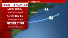
The northern extent of the snowfall will reach Connecticut before dawn Wednesday and could result in a light snow accumulation.
Following that storm system, another winter event could unfold Thursday in the form of snow, sleet, and freezing rain.
Then, another winter weather event will be likely at some point during the Presidents' Day Weekend.
We will keep you posted on this busy weather pattern!