
Thursday Weather Blog
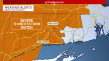
A severe thunderstorm watch is in effect for most of Connecticut through 9 p.m. Thursday. Any storms that pop up through this afternoon and evening have the potential to create damaging winds and heavy downpours.
Stream Connecticut News for free, 24/7, wherever you are.
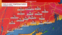
When it's not storming this afternoon, heat index values will be nearing 100 degrees for much of the state. High temperatures will warm into the upper 80s and lower 90s with high humidity.
Get top local Connecticut stories delivered to you every morning with the News Headlines newsletter.
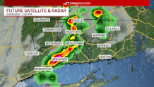
Thunderstorms are possible across the entire state, but they are expected to weaken slightly as they move eastward. New London County is not as hot and humid as the rest of us today, so their storm threat is the lowest. The threat will diminish shortly after the sun sets.
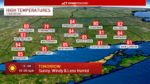
Skies will gradually clear through tonight as less humid air moves into southern New England. The first day of summer tomorrow will be sunny and breezy with northwest wind gusts potentially up to 35 miles per hour.
Temperatures will warm back up through the weekend ahead of potentially record heat next week. Heat index values will likely exceed 100 degrees a few times before the end of June.
