
Tuesday Weather Blog
An Extreme Heat Warning continues through this evening, due to the potential for heat index values to reach 110 degrees. Continue to stay safe in the heat by staying shaded and hydrated as much as possible.
Stream Connecticut News for free, 24/7, wherever you are.

Today will feature increasing winds from the west, keeping a sea breeze from forming, so it will be very hot down to the beaches. Humidity levels will drop off a bit, but it will be tough to feel it with the very high temperatures.
Get top local Connecticut stories delivered to you every morning with the News Headlines newsletter.

A rough combination of very hot temps and some humidity will make for dangerous conditions this afternoon.
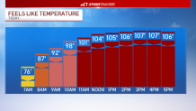
Actual temperatures will warm to near 100 degrees this afternoon. If we hit 100 degrees in Hartford, it would be the first 100-degree day since 2019, and the earliest occurrence of a 100F in a calendar year (on record), and the 28th occurrence in history . Wednesday will be another scorcher, but it will turn drastically cooler Thursday.

Along with the cooler temperatures, scattered rain showers will be likely late Wednesday night through Thursday.