
Tuesday Night Weather Blog
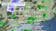
A nice night is underway under a partly cloudy sky. There is the chance we get a glancing blow of light rain showers in southeast Connecticut, between midnight and 6 a.m., but nothing major.

On Wednesday, we'll have sun to start the day and a few showers to finish the daylight hours. A cold front will spark isolated rain and snow showers in the afternoon. Some wet snowflakes can't be ruled out with these showers!
Get top local stories in Connecticut delivered to you every morning. Sign up for NBC Connecticut's News Headlines newsletter.
Following the minor shower chance Wednesday afternoon, Thursday will be mostly sunny and dry. A few passing mixed showers will be possible again Thursday night, but once again, nothing major. Our next, bigger weather change will be this weekend.
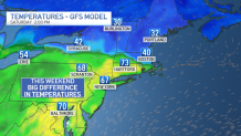
This weekend, we'll be on the edge of a cold and warm air mass. Temperatures will be in the 70's on the warm side, and 30's on the cold side. This always makes it tricky for our forecast, as a slight shift in the weather pattern will drastically change our conditions.
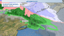
A few rain showers will be possible on Saturday as the boundary (of cold and warm air) moves across Connecticut. As of the latest forecast, Sunday appears to be the cloudier, wetter, and cooler weekend day.

This weekend, we'll have a brief chance to see a partial solar eclipse. This will happen at sunrise Saturday morning, but could be impacted by cloud cover.