
Saturday Weather Blog
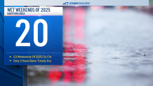
It was another wet Saturday, it now marks the 15th weekend in a row that we've had some sort of rainfall on either a Saturday, Sunday, or both days. The last time we had a completely dry weekend at BDL was February 22nd & 23rd. In fact, out of the 23 weekends of 2025 so far, 20 of them have had wet conditions.
Stream Connecticut News for free, 24/7, wherever you are.
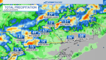
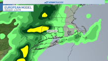
Some locations picked up over an inch of rainfall this afternoon.
Get top local Connecticut stories delivered to you every morning with the News Headlines newsletter.
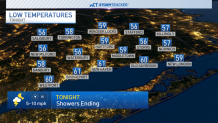
The good news as we move through tonight is that the showers will taper off and we'll start Sunday dry with a mix of clouds and sun. Temps tonight will fall back to the mid to upper 50s with areas of patchy fog as well.
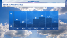
Sunday afternoon will see partly to mostly cloudy skies with temperatures warming into the middle to upper 70s. Dew point temperatures are expected to drop, so it will feel less muggy!

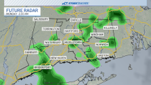
A small chance for rain is possible overnight Sunday and into Monday morning with most of those showers remaining light.
We'll have a better chance for rain on Tuesday with a rumble of thunder not out of the question as well.
Temps for the first half of the week will be cooler in the lower 70s but after Tuesday we'll start to warm up again with highs back in the 80s by the middle of the week.
The middle of the week also remains dry but we'll be keeping an eye on another round of rain by next weekend.