Monday Weather Blog
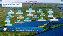
It is not going to be the prettiest end to March or start of the workweek. Dense fog will lift to cloudy skies with a few sunny breaks possible. The best chance of sunshine will be in western Connecticut. Temperatures will creep up into the 60s, for some in north-central CT, it may take all day to turn milder!
Scattered showers are possible later this afternoon, but the best chance of heavy rain and thunder is after 8pm. Downpours can continue through about 2:00 A.M. Increasing southerly winds will gust over 30 mph later today.
Get top local stories in Connecticut delivered to you every morning. Sign up for NBC Connecticut's News Headlines newsletter.
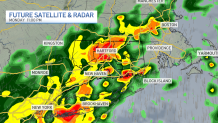
Future radar shows some organized thunderstorm activity this evening. 1"-2" of rain can fall bringing the risk of some urban street flooding.
This will bring a little instability to the atmosphere ahead of the chance for a few thunderstorms by the evening.

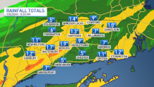
1-2 inches of rainfall are possible across much of the state through Monday night. Higher rainfall totals are expected in areas where thunderstorms are more likely.
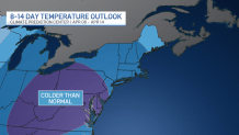
Finally, this is no way to start April!! Cooler than normal temperatures for several days, right into mid-April.
We'll be keeping a close eye on the forecast for the home opener of the Hartford Yard Goats on Friday. Right now, a few showers look possible in the morning with drier conditions ahead of the first pitch. Stay tuned.