Thursday Weather Blog
After a brief break, scattered showers and thunderstorms have returned to Connecticut. We'll continue to track rain chances through the rest of your Thursday.
Stream Connecticut News for free, 24/7, wherever you are.

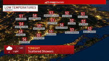
Scattered showers will be possible through the night with cloudy skies and calmer winds. Temperatures will drop into the 50s.
Get top local Connecticut stories delivered to you every morning with the News Headlines newsletter.
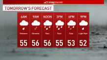
Friday will be closer to a washout with widespread rain likely through tomorrow. Temperatures won't move too much through the day, and we likely won't see much--if any--dry time.
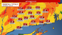
Model data supports another 1"-3" of rain through Friday, possibly more. The rainy start to May has helped lift us out of our drought, but too much rain in a short amount of time can lead to flooding concerns.
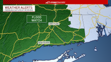
This could lead to more poor drainage and street flooding. We will monitor smaller rivers and streams--especially the Connecticut River into the coming days. There is a Flood Watch in effect for parts of Connecticut through Saturday morning.
Saturday could see a few morning showers closer to the Massachusetts border, but rain and clouds look to clear out ahead of Mother's Day!

The Connecticut shoreline should dry out Friday night and stay that way through the weekend. Temperatures will warm into the 60s Saturday before the 70s on Sunday.