
Saturday Weather Blog
Welcome to the last weekend of March! We're tracking a backdoor cold front sink south from northern New England, bringing much colder air to Connecticut. The front will push through the state from northeast to southwest through the course of the day.
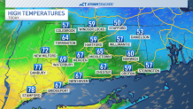
Temperatures will cool through the midday and afternoon hours beginning in the NE hills. By this evening, all of Connecticut is back in the 40s as rain chances return.
Get top local stories in Connecticut delivered to you every morning. Sign up for NBC Connecticut's News Headlines newsletter.
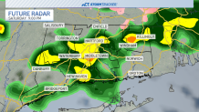
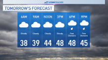
We'll cool into the 30s and 40s tonight as fog develops late. Most of Sunday will be cloudy, foggy and cooler with high temperatures in the upper 40s and lower 50s. Rain chances return late tomorrow as another wave of showers moves across the state.
We're tracking the chance for even a few rumbles of thunder on Monday evening as the final wave of this system impacts southern New England. Rainfall totals through Monday night could be between 1-2 inches. Lingering showers will exit early Tuesday, and we'll stay dry through Wednesday. Another rain chance returns on Thursday.
