Monday Weather Blog
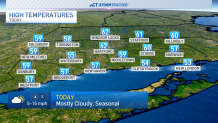
High temperatures will warm into the upper 50s and lower 60s this afternoon with mostly cloudy skies. Winds are much calmer today, but you could feel a little breeze out of the south this afternoon.
Tonight is cloudy as temperatures only fall into the upper 40s and lower 50s. The evening should be dry, but scattered showers are possible closer to midnight.
Get top local stories in Connecticut delivered to you every morning. Sign up for NBC Connecticut's News Headlines newsletter.

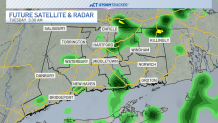
A few showers are possible through the early morning hours of Tuesday, but we should be dry before the sun rises. Patchy fog is possible to begin Earth Day before sunshine takes over.
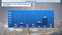
High temperatures should be able to warm into the 70s for the entire state tomorrow with winds out of the west. We'll remain above average through the rest of the week, potentially warming even further on Friday as a warm front approaches the region.

Our best chance for rain comes Friday night and into Saturday as a cold front moves through after Friday's warm front. We should be dry by Sunday.
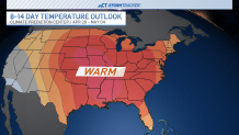
Temperatures look to stay above average through the 10-day forecast--and beyond. The Climate Prediction Center favors warm conditions through the rest of April and the beginning of May.