Friday Weather Blog
You know the saying "March is in like a lion and out like a lamb"? Well, the opposite is happening this year.
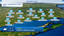
The last Friday of March is pretty nice, though. Today is cloudier and warmer than yesterday with high temperatures in the upper 50s and lower 60s.
Get top local stories in Connecticut delivered to you every morning. Sign up for NBC Connecticut's News Headlines newsletter.
Scattered showers are possible as early as this evening, and we'll track rain chances through the overnight hours. Temperatures will fall into the 40s by Saturday morning.

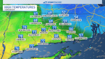
Tomorrow is the day where we could see a 30-degree divide across the state at the same time. We will have to watch exactly where this boundary sets up on Saturday. Areas closer to New York City will warm into the 70s. Those closer to Boston will likely top out in the 50s.
Temperatures for all of Connecticut will cool into the upper 40s and lower 50s on Sunday with a few more rain showers possible through the end of the weekend. A better rain chance comes on Monday when temperatures warm back into the 60s. We'll cool below average for the first few days in April.
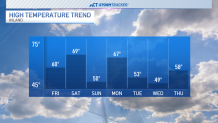
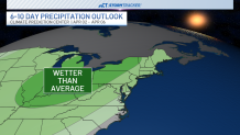
While the last few days of March feature rain chances, the beginning of April will see the same! We're tracking the chance for more rain by Thursday, and that has the potential to linger into the first weekend of the new month.