Saturday Weather Blog
Happy weekend! We're tracking a backdoor cold front sink south from northern New England, bringing much colder air to Connecticut. The front will be draped along the Mass Pike (I-90) at daybreak Sunday morning, then push through the state from northeast to southwest through the course of the day.
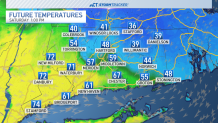
When this backdoor cold front pushes through, it will plummet temperatures into the 30's in northeast CT, while SW CT basks in the 70's!
Get top local stories in Connecticut delivered to you every morning. Sign up for NBC Connecticut's News Headlines newsletter.
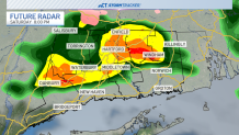
Most of the weekend will be dry, but a few batches of rain showers will pass through the state. A batch of rain will be likely Saturday evening, then most of Sunday should be dry (just cloudy).
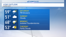
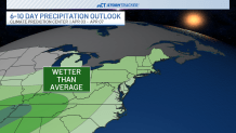
Sunday will be the cooler/cloudier day of the two weekend days, and then we will have the chance of thunderstorms on Monday. Tuesday turns cooler as our temperature roller coaster continues. More April showers are on the way for the first week of the upcoming month, so keep that rain jacket and umbrella handy!