Saturday Weather Blog
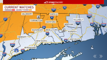
New this afternoon: The Storm Prediction Center and National Weather Service have put Hartford, Tolland, and Litchfield Counties until 8 p.m. Saturday for the threat of strong winds, heavy rain, and small hail.
Stream Connecticut News for free, 24/7, wherever you are.
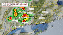
A boundary will likely develop along and northwest of I-84 early this afternoon. The threat for stronger storms will be with us through the evening hours. Southeast Connecticut should stay dry and out of the threat, but rain chances will be possible for all of the state into tonight.
Get top local Connecticut stories delivered to you every morning with the News Headlines newsletter.
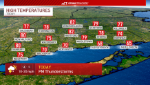
Saturday will see dry and sunnier conditions through the morning, but that will fuel the atmosphere with energy to produce thunderstorms later in the day. Temperatures will warm into the 70s and 80s ahead of the storm chance.
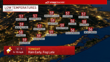
Rain should end before midnight, and fog will likely develop into Sunday morning. Temperatures will drop into the 50s overnight.
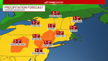
Sunday will begin with fog, but tomorrow morning should stay dry. Shower chances return late in the day, and we'll track waves of rainfall through Monday, Tuesday and even early Wednesday. This could allow for many areas to pick up several inches of rain.