Monday Weather Blog
Spring is in the air tonight with warm temperatures and heavy thunderstorms. We're watching developing thunderstorms which will become more likely as the night rolls along.
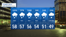
Most of the rain and thunderstorms will wait until after dark this evening, pushing through at their heaviest intensity around midnight tonight.
Get top local stories in Connecticut delivered to you every morning. Sign up for NBC Connecticut's News Headlines newsletter.
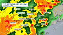
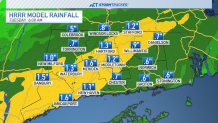
This rain may be heavy, so use caution traveling tonight because it will be difficult to see through the downpours. Rainfall may reach up to 1 to 2 inches in a few communities!
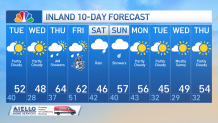
Temperatures will get cool after the rain ends, and by sunrise Tuesday it'll be around 40 degrees as the sky quickly clears.

Looking ahead this week, the sun will reappear Tuesday and it'll shape up to be a nice day. The weather will be turning colder with highs in the 50's and 40's Tuesday and Wednesday, then warming Thursday and Friday, returning to the 60's. We will see rain return at the end of the week. Rain will also stick around this weekend, possibly interrupting our weekend plans.