
Tuesday Weather Blog
As the work week continues, a rising temperature trend is underway. Wednesday is expected to be another warm summer day, with temperatures climbing into mid to upper 80s inland, and low to mid 80s expected along the shore.
Stream Connecticut News for free, 24/7, wherever you are.
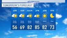
Partly cloudy skies are expected throughout the day, but skies may seem more obstructed than usual. Wildfire smoke from over 75 fires in the Canadian Provinces of British Columbia, Alberta, Saskatchewan, and Manitoba will move into New England.
Get top local Connecticut stories delivered to you every morning with the News Headlines newsletter.
This smoke will be elevated, bringing milkier skies, and a more vibrant sunrise and sunset across the state.

Temperatures continue to climb on Thursday, with many across the state seeing their first 90-degree day since late August. This marks 280 days since the last 90 degree reading at Bradley International Airport.
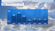
A cold front will move through Friday evening, bringing with it an opportunity for light rainfall. There is a chance for some isolated heavy showers and downpours, although they will be short-lived.
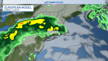
There is high uncertainty as to whether or not the weekend remains dry. Saturday has a chance of some showers, with the risk of rainfall decreasing on Sunday. Either way, temperatures will be much less beach-like than the middle of this week.