Sunday Weather Blog
It was a beautiful Easter Sunday with plenty of sunshine, seasonal temps in the low to mid 60s, and winds gusting up to 40 mph.
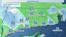
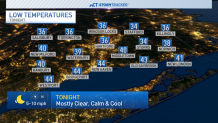
Tonight we'll see the winds decreasing with temperatures falling into the 30s and 40s. Areas that tend to be a little cooler could wake up with some patchy frost.
Get top local stories in Connecticut delivered to you every morning. Sign up for NBC Connecticut's News Headlines newsletter.
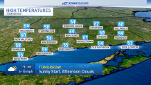
After a sunny start to Monday morning we'll see clouds increase through Monday afternoon temperatures returning to the upper 50s and low 60s across the state.
A few showers are possible closer to midnight Monday evening and into early Tuesday morning.
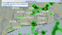
Most of Tuesday will be dry with sunshine returning for the afternoon with temps reaching the 70s.
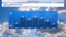
Otherwise, most of the work week can be classified as warm and dry.
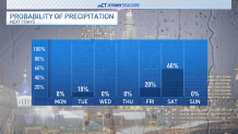
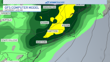
With a few showers returning by next weekend.
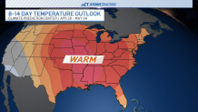
Temperatures look to stay above average through the 10-day forecast--and beyond. The Climate Prediction Center favors warm conditions through the rest of April and the beginning of May.