Tuesday Weather Blog
Overnight rain has moved out and clearing skies will develop this morning. This transition will lead to beautiful afternoon and evening across the region. High temps will move up into the 70s inland and some upper 60s to lower 70s at the Shoreline.

Partly cloudy to clear skies will dominate tonight with lows in the 40s to lower 50s.
Get top local stories in Connecticut delivered to you every morning. Sign up for NBC Connecticut's News Headlines newsletter.

We'll remain above average through the rest of the week, potentially warming even further on Friday as a warm front approaches the region.

After a work and school week that is mainly fair, warm, and dry....our next significant rain threat appears on Saturday. The timing is still difficult to nail down, but it will rain at some point Saturday. Below is the slower of the solutions (the EURO) and beneath that is the quicker (by 12 hours) the American GFS. We have time to fine tune this over the next few days!


Some locations could pick up close to an inch of rainfall.

We should be dry by Sunday.
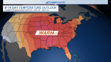
Temperatures look to stay above average through the 10-day forecast--and beyond. The Climate Prediction Center favors warm conditions through the rest of April and the beginning of May.