
Sunday Weather Blog
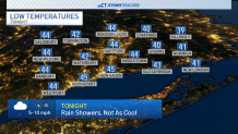
Temperatures won't cool down too much tonight as scattered showers remain possible. Winds will shift from the east to the south and slowly pick up by sunrise.
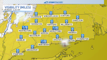
It will be very foggy tonight and for the morning commute so give yourself a few extra minutes as you're heading out the door.
Get top local stories in Connecticut delivered to you every morning. Sign up for NBC Connecticut's News Headlines newsletter.
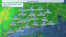
Temperatures on Monday look to climb back into the 60s as southerly winds gust up to 30 miles per hour.
This will bring a little instability to the atmosphere ahead of the chance for a few thunderstorms by the evening.

Timing is important with this system--the later storms roll through, the less energy they'll have to work with. As they progress west to east, storms will weaken as they move across Connecticut.

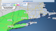
1-2 inches of rainfall are possible across much of the state through Monday night. Higher rainfall totals are expected in areas where thunderstorms are more likely.

Those locations could have minor flooding issues in the form of ponding on roadways or a quick rise in small streams.
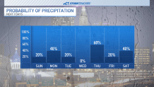
Rain is most likely from Monday evening through the overnight hours. A few lingering showers are possible into early Tuesday before clouds decrease through April Fools' Day. Most of Tuesday and Wednesday will be cooler and dry before rain chances return Wednesday night. Thursday will be warmer with showers likely.
We'll be keeping a close eye on the forecast for the home opener of the Hartford Yard Goats on Friday. Right now, a few showers look possible in the morning with drier conditions ahead of the first pitch. Stay tuned.
