Saturday Weather Blog
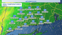
Welcome to the last weekend of March! It either felt like summer or winter across the state with a sharp temperature divide. Northeastern CT remained in the upper 40s while the Southwestern part of the state was able to climb into the upper 70s to 80°!

Tonight temps will continue to cool with rain chances increasing.
Get top local stories in Connecticut delivered to you every morning. Sign up for NBC Connecticut's News Headlines newsletter.
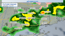
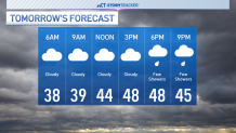
We'll cool into the 30s and 40s tonight as fog develops late. Most of Sunday will be cloudy, foggy and cooler with high temperatures in the upper 40s and lower 50s. Rain chances return late tomorrow as another wave of showers moves across the state.
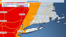
Temperatures on Monday look to climb back to the mid 60s which could lead to a little bit of instability. A risk of severe weather exists off to our west for a few stronger thunderstorms.
As the storms get closer to CT they are expected to weaken but a couple could still produce gusty winds, and heavy downpours.
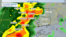
Rainfall totals through Monday night could be between 1-2 inches.

Minor flooding in the usual trouble spots and ponding on roadways will be possible with the storms that move through CT.
Lingering showers will exit early Tuesday, and we'll stay dry through Wednesday. Another rain chance returns on Thursday with mid temps back in the mid to lower 60s.
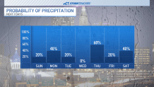
We'll be keeping a close eye on the forecast for the home opener of the Hartford Yard Goats on Friday. Right now a few showers look possible in the morning with drying conditions by Friday night.

Another wave of rainfall will move in by next weekend with temps looking to remain in the mid 50s.