
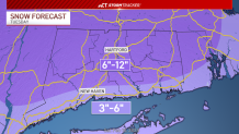
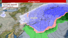
Our StormTracker meteorologists are tracking a storm that could bring several inches of snow to parts of the state late Monday through Tuesday afternoon.
Most of the state could see between 6 and 12 inches of snow. Three to six inches is likely along the immediate shoreline.
Get top local stories in Connecticut delivered to you every morning. Sign up for NBC Connecticut's News Headlines newsletter.
The precipitation will start late Monday into early Tuesday. Some rain and/or mixing is possible along the shoreline.
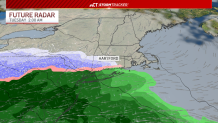
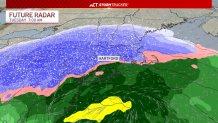
The precipitation will change to all snow by Tuesday around noon.
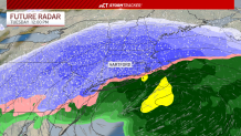
There will be a few hours of widespread snow during the day on Tuesday before it quiets down in the evening.
On top of the snow, there will be strong wind gusts. Up to 40 mph winds are possible.
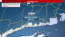
A Winter Storm Watch has been issued for parts of Fairfield, Hartford, Litchfield, Middlesex, New Haven, New London and Windham counties starting Monday night. The watches end at various times on Tuesday.
Local


You can get the latest information on the storm on the StormTracker blog here.
Be prepared for your day and week ahead. Sign up for our weather newsletter.