Active winter weather will continue for the next several days with multiple chances for snow along with colder temperatures.
Temperatures have been dropping throughout the day on Tuesday.
Stream Connecticut News for free, 24/7, wherever you are.
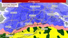
A cold front is bringing windy weather along with those falling temperatures. Wednesday will be another cold day ahead of a system arriving Thursday morning.
That system will bring snow, sleet, freezing rain, and rain for the entire state.
Get top local Connecticut stories delivered to you every morning with the News Headlines newsletter.
The timing is for the snow and sleet to start in the morning, transitioning to a wintry mix by midday, and then a cold rain by the afternoon.
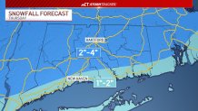
Snow and sleet accumulation is a widespread 2 to 4 inches for most towns across Connecticut with 1 to 2 inches along the shoreline.
Impacts to roads will be possible, including slick spots and delays.
A break in the weather is expected Friday before another storm system moves in Saturday evening and overnight.