Our StormTracker meteorologists are tracking two chances for snow in the next few days.
Clouds will increase Monday night ahead of a chance for flurries into Tuesday morning.
Stream Connecticut News for free, 24/7, wherever you are.
Snow squalls are possible Tuesday, but they're more likely on Wednesday afternoon.
Snow squalls are brief, whiteouts that occur with heavy bands of snow. They don't last long, maybe 15 to 20 minutes, but can cause hazardous travel in an instant.
Get top local Connecticut stories delivered to you every morning with the News Headlines newsletter.
Snow squalls are possible in northwest Connecticut between 7 and 9 a.m. on Tuesday. Then on Wednesday, squalls are possible between 3 and 6 p.m.
Temperatures will slowly fall through Tuesday as skies briefly clear. By late Tuesday night, we're tracking a better chance for minor snow accumulations.

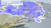
Light snow will fall over much of the state through Wednesday morning.
Snow totals will likely be less than an inch for much of Connecticut, with up to 2 inches possible near the Berkshires and Northeast Hills.